Map Projections:
I chose Brazil as my focus area for projections because of it's size. Brazil is a relatively large country, making it easier to see the changes in distortion when comparing different types of maps.
I was able to create these three projections by first finding the latitude and longitude coordinates of Brazil's capital, Brasilia; 15.667 S 47.43 W. Once I had pin pointed that on the map, I entered numbers around -15 into the North and South coordinates and numbers near -47 into the East and West coordinates. After a process of guess and check, I was able to successfully zoom-in and center Brazil on the map.
The three type of maps I have selected are the Mercator, the Robinson and the Cylindrical Equal Area projections.
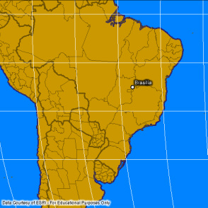
Mercator:

Mercator projection
The Mercator projection was created as a navigation tool. The square grid and parallel lines of latitude and longitude make it easy to use. The straight lines and rectangular shape also make it perfect for wall maps, textbook, newspapers, etc. It is now one of the most widely used projections. However; the size of some countries on the Mercator projection are very distorted. As you move farther North or farther South on the map, the size distortion increases. For example, Greenland appears to be the same size as South America, when in fact it is about 1/8 of the size.
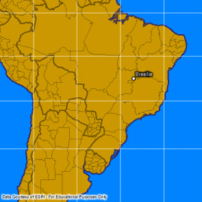
Robinson:
Robinson projection
Unlike the Mercator projection, the Robinson projection is more of an ovular shape with evenly spaced, curved lines of latitude and longitude. The map is slightly distorted in all aspects. The shape, distance, size and direction are all not quite accurate. The sizing towards the poles, however, is more accurate than that of the Mercator. This projection was created to be pleasing to the eye not for accurace, which lead to much distortion.
Cylindrical Equal Area:
Cylindrical Equal Area projection
Cylindrical Equal Area projections have straight meridians and parallels. The meridians are equally spaced and the parallels unequally spaced. Towards the equator there is a large amount of vertical exaggeration. In middle latitude regions there is significant vertical compression; this is the reason for the shape and size distortion of Brazil. This type of map projection is not very commonly used and is often criticized by cartographers. It is most useful for geographical comparisons.
Site and Situation:
Site is the exact location of a place, such as latitude and longitude coordinates or a specific address. Situation, on the other hand, is the location of something relative to other places. For example, if I was describing the location of Brazil I could say "it is located South of North America."
Site and Situation play a large role in a countries economy. Brazil's agriculture flourishes because of its close proximity to a water body. This also allows them to easily export goods such as various foods and textiles, contributing to their economical activity.
Site and Situation play a large role in a countries economy. Brazil's agriculture flourishes because of its close proximity to a water body. This also allows them to easily export goods such as various foods and textiles, contributing to their economical activity.
