Analysis:
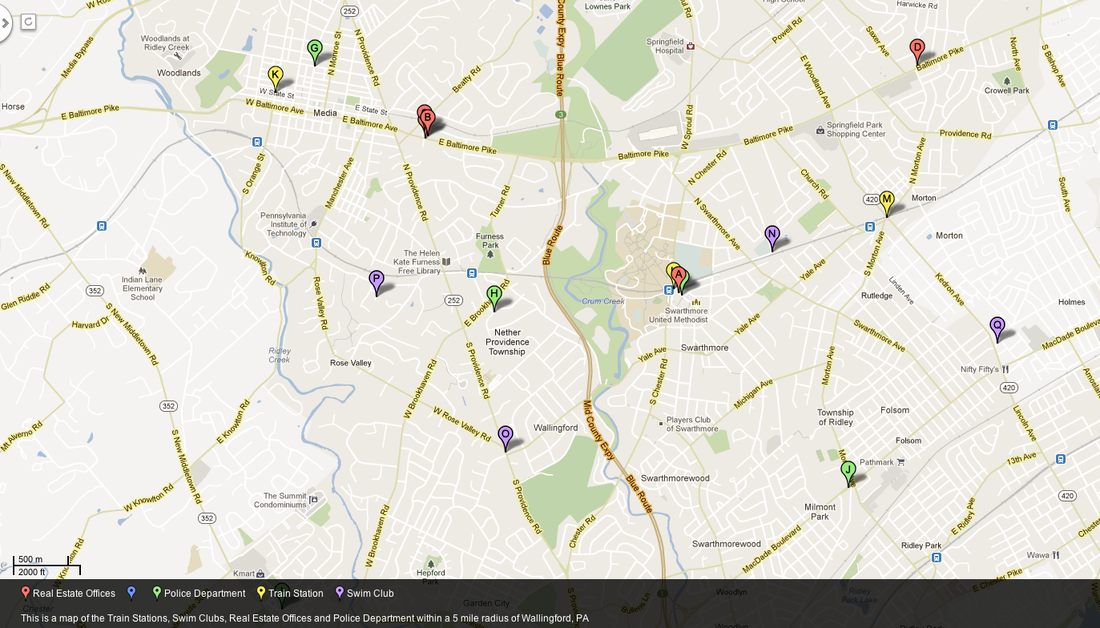
In order to create this map, I created a spread sheet with the adresses, phone numbers, services types and business names of the train stations, swim clubs, real estate offices and police departments within 5 miles of Wallingford, PA. After I had done this, I copy and pasted the information from the spreadsheet onto batchgeo.com, clicked create map, and I was done! In order to view the specific services pin-pointed on the map, click on the "batchgeo.com" button located below it and it will take you to the original website!
This service is an application of GIS. GIS is defined as a system that allows you to capture, store and create maps, whereas GPS just shows the exact location you are trying to find.
GIS: Global Information System: capture, store, query, analyze and display geographic data. Various Layers
GPS: Global Positioning System: accurately determines the precise position of something on earth
Density: the frequency with which something exists within a given unit of area. As it applies to the map I've created, there is a fairly low density of people in the area and therefore it is unnecessary to have a high density of services like swim clubs, police departments and train stations. There is, however a high density of real estate agencies in a small area. This would only make sense because in a district such as this one, there is always a lot of people moving to the town or relocation within the town.
Pattern: the geometric or regular arrangement of something in space. There doesn't appear to be much of a pattern in the map I have created. The only real pattern lies within the police departments. The are located about equidistant from each other which would make sense because each town would want to have their own police and as long as the headquarters are spread equally, no part of a town will ever go unprotected.
Agglomeration: the clustering of a specific type of business. There is a great amount of agglomeration that can be seen on my map in the real estate agencies. On Baltimore Pike, there are 3 real estate offices located right next to each other. This would allow not only for good competition, but it makes it easier, when dealing with a buyer and a seller from two different agencies, to communicate with agents, mortgage brokers, etc.
Concentration: the extent of a features spread over space. In the map I have created, most of the services are located in the same general area within each town. For example, almost all the services located in Swarthmore are concentrated right in the center of town, on Park Avenue.
Central Place Theory: This is a theory attempts to explain the reasons behind the patterns, sizes, and number of cities and towns around the world. It suggests that market areas are arranged in regular patterns. A hexagon is used to show the larger and smaller settlements or towns within a given area. Smaller hexagons represent more common markets such as convenience stores, while larger hexagons represent less common restaurants. For example, the market area of a restaurant chain like mcdonalds would be a part of a smaller hexagon. McDonalds are everywhere you go so people are less willing to travel far for it. A famous restaurant in Philly would have a much larger market area (large hexagon) because people from farther away would be willing to travel to experience it! This theory helps to answer the question of how far people are willing to travel for certain goods and services.
